High precision data capture technology developed to map the location and condition of roadside assets and above ground utility infrastructure could soon be used to help prevent potholes from forming.
Join other savvy professionals just like you at CIHT. We are committed to fulfilling your professional development needs throughout your career
National mapping agency Ordnance Survey and technology company Mobileye announced yesterday a new trial with Northumbrian Water to create a detailed roadside infrastructure dataset of Britain.
Cars and vans fitted with cameras capture a street level view of the highway environment to record the position of utility infrastructure including manhole covers and drainage grates, as well as street furniture such as traffic lights and road signs.
Data is fed into a central cloud-based repository for cross referencing with existing data sets in order to populate a digital street map that can be continually updated. One aim of the exercise is to allow companies to more effectively monitor the condition of their assets when planning maintenance programmes.
In due course the technology trial will also start mapping standing surface water – to identify the source of potential leaks – and tree foliage cover around overhead cables, to help pinpoint vegetation that needs attention.
Future years could also see such technology assist autonomous vehicles in navigating highways safely, it was said.
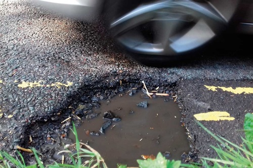
But it is the potential use of the data capture system to identify future highway defects before they become problematic – and to pinpoint road markings that require renewal – that could most excite local authority transport teams.
Ordnance Survey’s interim chief executive Neil Ackroyd said: “We are talking to local authorities about road condition surveys. Determining a pothole before it starts to break the (asphalt) to help with predictive maintenance is a focus.”
Mobileye chief executive Professor Amnon Shashua predicted that 24 million vehicles in the UK will be equipped with devices able to send highway asset data within three years. “This information is critical for smart cities to continuously know what is happening to infrastructure assets,” he said.
“It is as if you have a person in the car making notes (about things) such as whether a traffic sign is crooked and needs fixing.”
Join other savvy professionals just like you at CIHT. We are committed to fulfilling your professional development needs throughout your career
{{item.AuthorName}} {{item.AuthorName}} says on {{item.DateFormattedString}}: